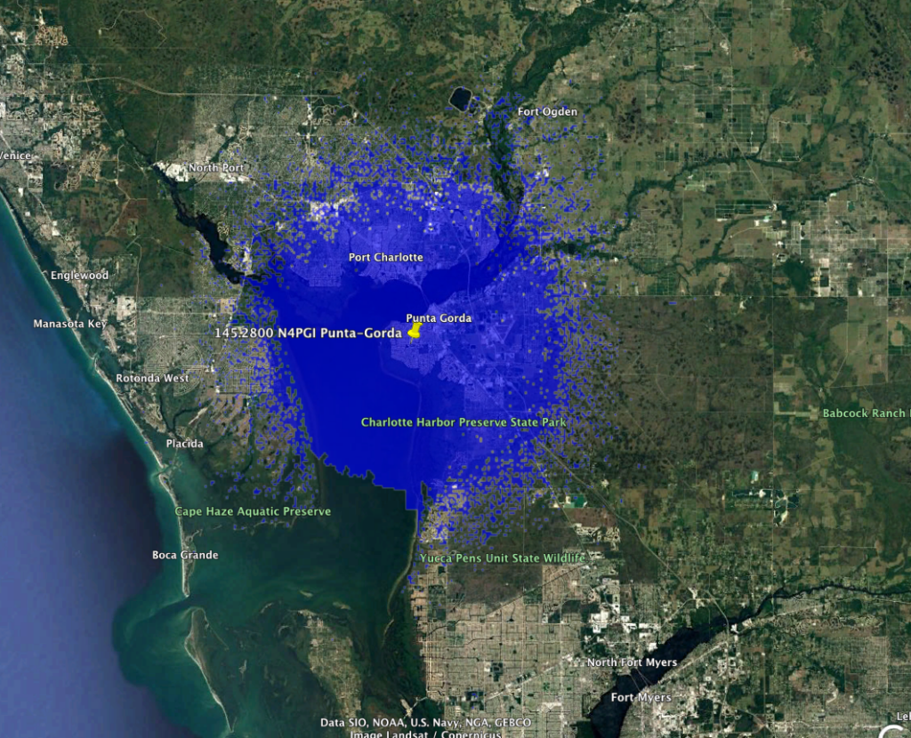
This is a new Narrow Band FM repeater on a 10 kHz channel in Punta Gorda. It’s running a 136.5 Hz CTCSS and shouldn’t cause any issue to the adjacent users.
145.2800 N4PGI Punta Gorda 3636 Service Contour
====FASMA COORDINATION RECORD 3636====

Record ID      : 3636
Coord Date     : 2022-03-11
Update Date    : 2022-03-11
Orig Cord Date : 2022-03-11
Holder         : Nora Giardina
Trustee        : Nora Giardina, N4PGI
URL            : No URL On File
County         : Charlotte
City           : Punta Gorda
Lat, Lon       : 26.91, -82.07
Callsign       : N4PGI
Output Freq    : 145.2800 MHz
Input Freq     : 144.6800 MHz
Bandwidth      : 10.000 KHz
Emission 1     : 11K2F3E
Emission 2     :
ERP            : 34.3 Watts, +45.35 dBm
Antenna Height : 15.00 Meters
Access Tone Out: 136.5 Hz
Access Tone In : 136.5 Hz
Model          : https://plots.fasma.org/144/145.2800_N4PGI_Punta-Gorda_3636.kmz
Service        : 17 km
Interference   : 50 km
Adjacent 1     : 39 km

The coverage model is a standard KML format and may be viewed in google earth.
This is automatically generated based on your location, antenna height, ERP and
frequency.
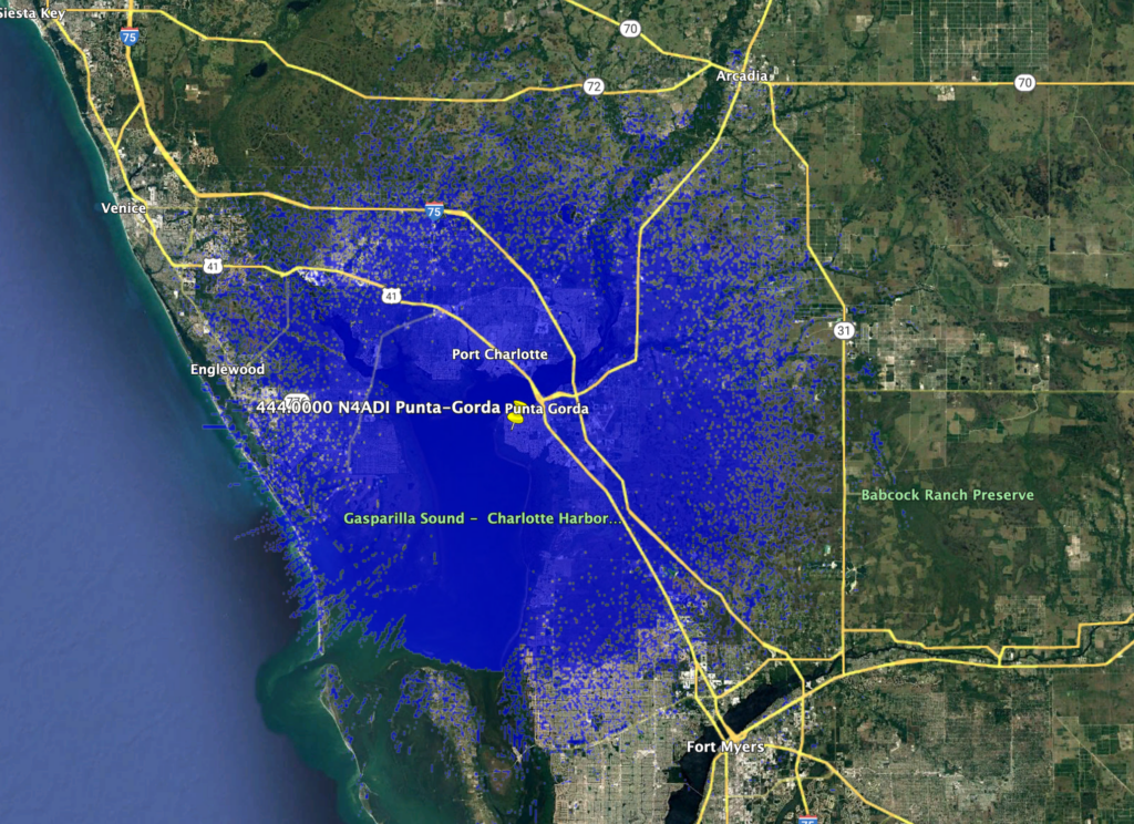
This is a new wideband FM and DStar repeater in Punta Gorda.
444.0000 N4ADI Punta Gorda Service Conour
====FASMA COORDINATION RECORD 3634====

Record ID : 3634
Coord Date : 2022-02-20
Update Date : 2022-02-20
Orig Cord Date : 2022-02-20
Holder : Joeseph Giardina Sr
Trustee : Joeseph Giardina Sr, N4ADI
URL : No URL On File
County : Charlotte
City : Punta Gorda
Lat, Lon : 26.91, -82.08
Callsign : N4ADI
Output Freq : 443.0000 MHz
Input Freq : 448.0000 MHz
Bandwidth : 12.500 KHz
Emission 1 : 7K60FXE
Emission 2 :
ERP : 230.1 Watts, +53.62 dBm
Antenna Height : 18.40 Meters
DMR CC : CC1 = 9, CC2 = 9
Model : https://plots.fasma.org/440/443.0000_N4ADI_Punta-Gorda_3634.kmz
Service : 31 km
Interference : 74 km
Features : Open

The coverage model is a standard KML format and may be viewed in google earth.
This is automatically generated based on your location, antenna height, ERP and
frequency.
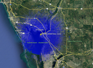
This is a new DMR repeater in Punta Gorda.
443.0000 N4ADI Punta Gorda Service Contour
====FASMA COORDINATION RECORD 3634====

Record ID : 3634
Coord Date : 2022-02-20
Update Date : 2022-02-20
Orig Cord Date : 2022-02-20
Holder : Joeseph Giardina Sr
Trustee : Joeseph Giardina Sr, N4ADI
URL : No URL On File
County : Charlotte
City : Punta Gorda
Lat, Lon : 26.91, -82.08
Callsign : N4ADI
Output Freq : 443.0000 MHz
Input Freq : 448.0000 MHz
Bandwidth : 12.500 KHz
Emission 1 : 7K60FXE
Emission 2 :
ERP : 230.1 Watts, +53.62 dBm
Antenna Height : 18.40 Meters
DMR CC : CC1 = 9, CC2 = 9
Model : https://plots.fasma.org/440/443.0000_N4ADI_Punta-Gorda_3634.kmz
Service : 31 km
Interference : 74 km
Features : Open

The coverage model is a standard KML format and may be viewed in google earth.
This is automatically generated based on your location, antenna height, ERP and
frequency.
FASMA will be presenting to the Gold Coast Amateur Radio Association Tuesday February 22 at 8pm Local Time. Everyone is encouraged to join via Zoom and the meeting invite is below.
Note the meeting starts at 7:30, but there will be a business meeting from 7:30-8:00
+1 929 205 6099 US (New York)
+1 301 715 8592 US (Washington D.C)
+1 312 626 6799 US (Chicago)
+1 669 900 6833 US (San Jose)
+1 253 215 8782 US (Tacoma)
+1 346 248 7799 US (Houston)
FASMA is happy to release an update the coordination form PDF. the new 1.12 PDF form has been through several revisions and has the required and optional information more clearly shown. In addition, drop-downs of list based items make this easier to use. The holder and trustee information is now side by side and easier to ensure it’s correct.
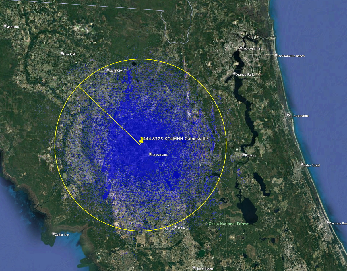
This is a new DMR/NBFM repeater in Gainsville. It looks to have a great coverage area based on the model of 61 km.
444.8375_KC4MHH_Gainesville_3631 Service Contour
====FASMA COORDINATION RECORD 3631====

Record ID      : 3631
Coord Date     : 2021-12-08
Update Date    : 2021-12-08
Orig Cord Date : 2021-12-08
Holder         : James A Carr
Trustee        : James A Carr, KC4MHH
URL            : http://kc4mhh.com
County         : Alachua
City           : Gainesville
Lat, Lon       : 29.71, -82.39
Callsign       : KC4MHH
Output Freq    : 444.8375 MHz
Input Freq     : 449.8375 MHz
Bandwidth      : 12.500 KHz
Emission 1     : 7K60FXE
Emission 2     : 11K2F3E
ERP            : 265.5 Watts, +54.24 dBm
Antenna Height : 167.00 Meters
Access Tone Out: 123.0 Hz
Access Tone In : 123.0 Hz
DMR CC         : CC1 = 1, CC2 = 1
Model          : https://plots.fasma.org/440/444.8375_KC4MHH_Gainesville_3631.kmz
Service        : 61 km
Interference   : 117 km
Features       : TG 3100, 3112, 3199, 31127 Static on Slot 1
               : BrandMeister Repeater ID:  312812

The coverage model is a standard KML format and may be viewed in google earth.
This is automatically generated based on your location, antenna height, ERP and
frequency.

Florida Amateur Spectrum Management Association, Inc.
This repeater has been confirmed off air by FASMA spectrum monitors and the trustee has failed to respond to repeated requests for updates since Jun 2020. As FASMA has no updates, this repeater is de-coordinated.
====FASMA COORDINATION RECORD 360====

Record ID      : 360
Coord Date     : 2019-11-27
Update Date    : 2016-09-30
Orig Cord Date : 1996-11-27
Holder         : Francisco Cabrera, WB4TWQ
Trustee        : Francisco Cabrera, WB4TWQ
URL            :
County         : Miami-Dade
City           : Miami
Lat, Lon       : 25.87, -80.27
Callsign       : WB4TWQ
Output Freq    : 145.1500 MHz
Input Freq     : 144.5500 MHz
Bandwidth      : 20.000 KHz
Emission 1     : 16K0F3E
Emission 2     :
ERP            : 500.0 Watts, +56.99 dBm
Antenna Height : 106.68 Meters
Access Tone Out: ERROR: TONE IS UNSET, PLEASE UPDATE RECORD!
Access Tone In : ERROR: TONE IS UNSET, PLEASE UPDATE RECORD!
Model          : https://plots.fasma.org/144/145.1500_WB4TWQ_Miami_360.kmz
Service        : ERROR: SERVICE MISSING km
Interference   : ERROR: INTERFERENCE MISSING km
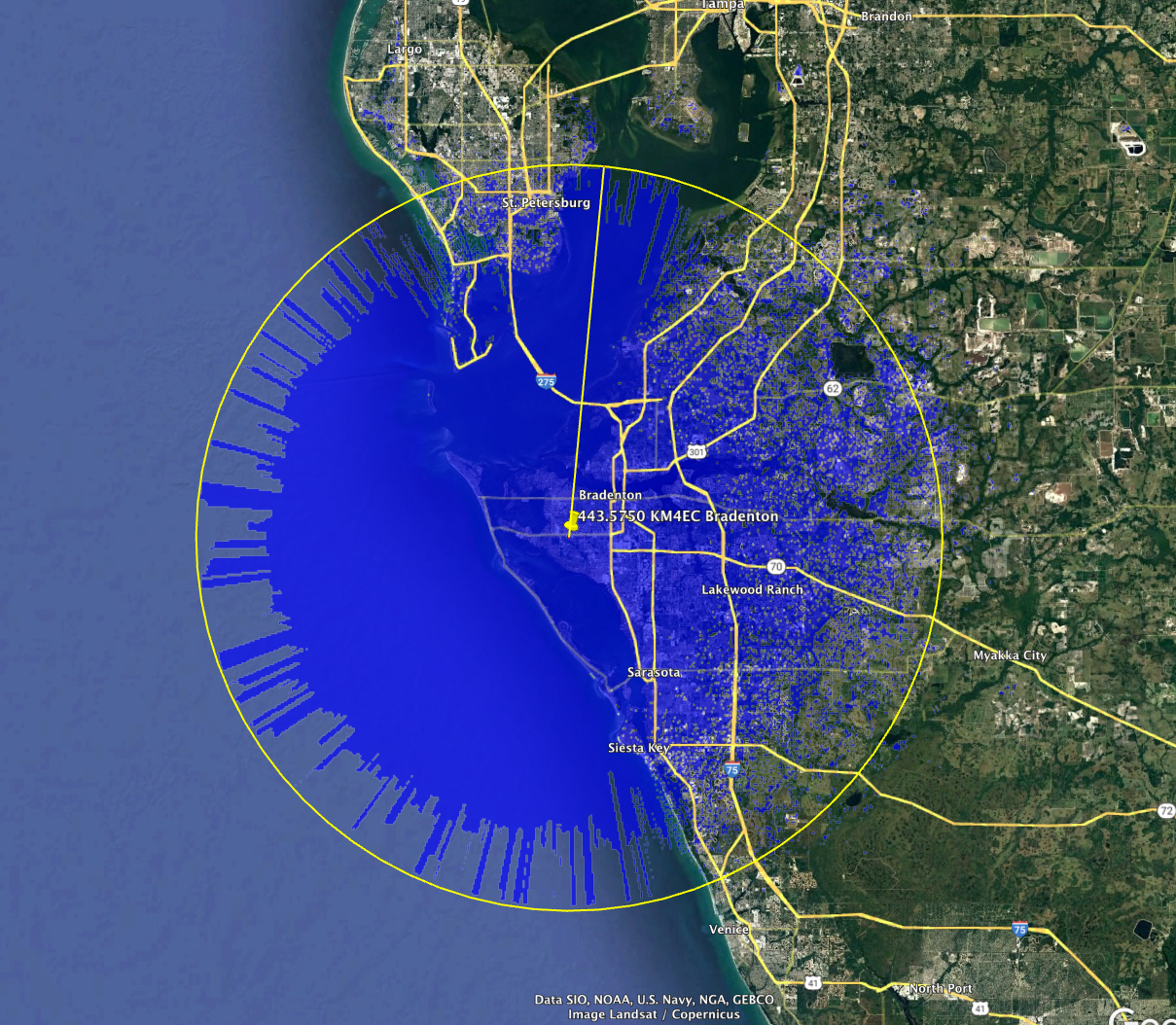
====FASMA COORDINATION RECORD 3630====

Record ID      : 3630
Coord Date     : 2021-12-02
Update Date    : 2021-12-02
Orig Cord Date : 2021-12-02
Holder         : Manatee County Emergency Support Group, Inc.
Trustee        : Jack W Ham, WB9KVD
URL            : https://www.mcesg.org/
County         : Manatee
City           : Bradenton
Lat, Lon       : 27.46, -82.62
Callsign       : KM4EC
Output Freq    : 443.5750 MHz
Input Freq     : 448.5750 MHz
Bandwidth      : 25.000 KHz
Emission 1     : 16K0F3E
Emission 2     :
ERP            : 75.2 Watts, +48.76 dBm
Antenna Height : 50.30 Meters
Access Tone Out: 103.5 Hz
Access Tone In : 103.5 Hz
Model          : https://plots.fasma.org/440/443.5750_KM4EC_Bradenton_3630.kmz
Service        : 38 km
Interference   : 85 km

The coverage model is a standard KML format and may be viewed in google earth.
This is automatically generated based on your location, antenna height, ERP and
frequency.

Florida Amateur Spectrum Management Association, Inc.
This is a multi-mode digital repeater newly setup in Lake Placid.
442.7375 KM4ECQ Lake Placid service contour
====FASMA COORDINATION RECORD 3616====

Record ID      : 3616
Coord Date     : 2021-11-06
Update Date    : 2021-11-06
Orig Cord Date : 2021-06-28
Holder         : Ryan J. Haynie
Trustee        : Ryan J. Haynie, KM4ECQ
URL            : http://km4ecq.ddns.net
County         : Highlands
City           : Lake Placid
Lat, Lon       : 27.30, -81.36
Callsign       : KM4ECQ
Output Freq    : 442.7375 MHz
Input Freq     : 447.7375 MHz
Bandwidth      : 12.500 KHz
Emission 1     : 8K10F1E
Emission 2     : 7K60FXE
ERP            : 129.4 Watts, +51.12 dBm
Antenna Height : 76.20 Meters
DMR CC         : CC1 = 1, CC2 = 1
P25 NAC TX     : 0x293
P25 NAC RX     : 0x293
Model          : https://plots.fasma.org/440/442.7375_KM4ECQ_Lake-Placid_3616.kmz
Service        : 50 km
Interference   : 99 km
Features       : MMDVM multimode
               : 6K25F7W, 4K00F1E, 7K60FXE, 8K10F1E, 9K36F7W
               : DMR CC1, P25 NAC 293, NXDN RAN1

The coverage model is a standard KML format and may be viewed in google earth.
This is automatically generated based on your location, antenna height, ERP and
frequency.
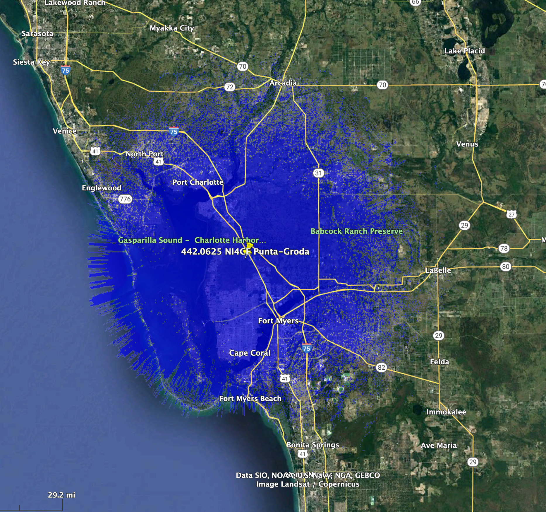
====FASMA COORDINATION RECORD 3627====
Record ID : 3627
Coord Date : 2021-11-03
Update Date : 2021-11-03
Orig Cord Date : 2021-11-03
Holder : West Central Florida Group, Inc.
Trustee : Matt Copeland, NC4FD
URL : http://www.ni4ce.org/
County : Charlotte
City : Punta Groda
Lat, Lon : 26.79, -81.96
Callsign : NI4CE
Output Freq : 442.0625 MHz
Input Freq : 447.0625 MHz
Bandwidth : 12.500 KHz
Emission 1 : 4K00F1E
Emission 2 :
ERP : 212.3 Watts, +53.27 dBm
Antenna Height : 76.20 Meters
NXDN RAN : 1
Model : https://plots.fasma.org/440/442.0625_NI4CE_Punta-Groda_3627.kmz
Service : 46 km
Interference : 94 km
Features : NXDN
The coverage model is a standard KML format and may be viewed in google earth.
This is automatically generated based on your location, antenna height, ERP and
frequency.
Florida Amateur Spectrum Management Association, Inc.