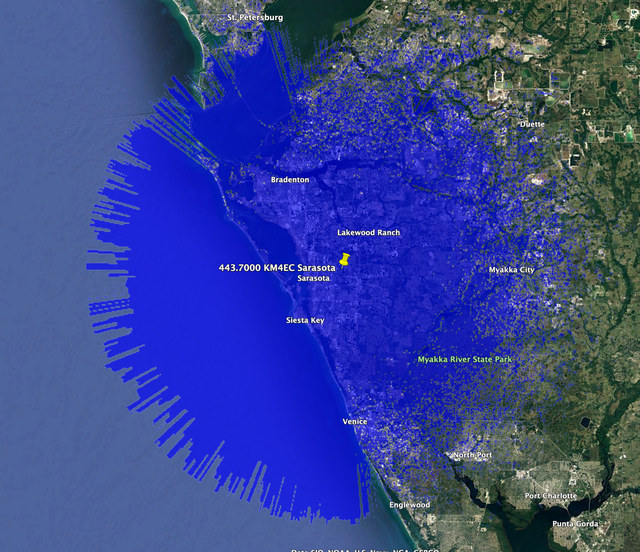
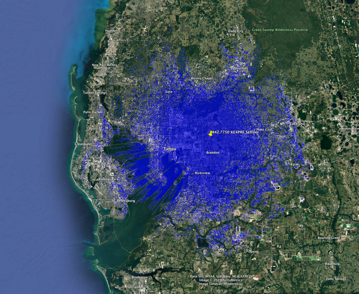
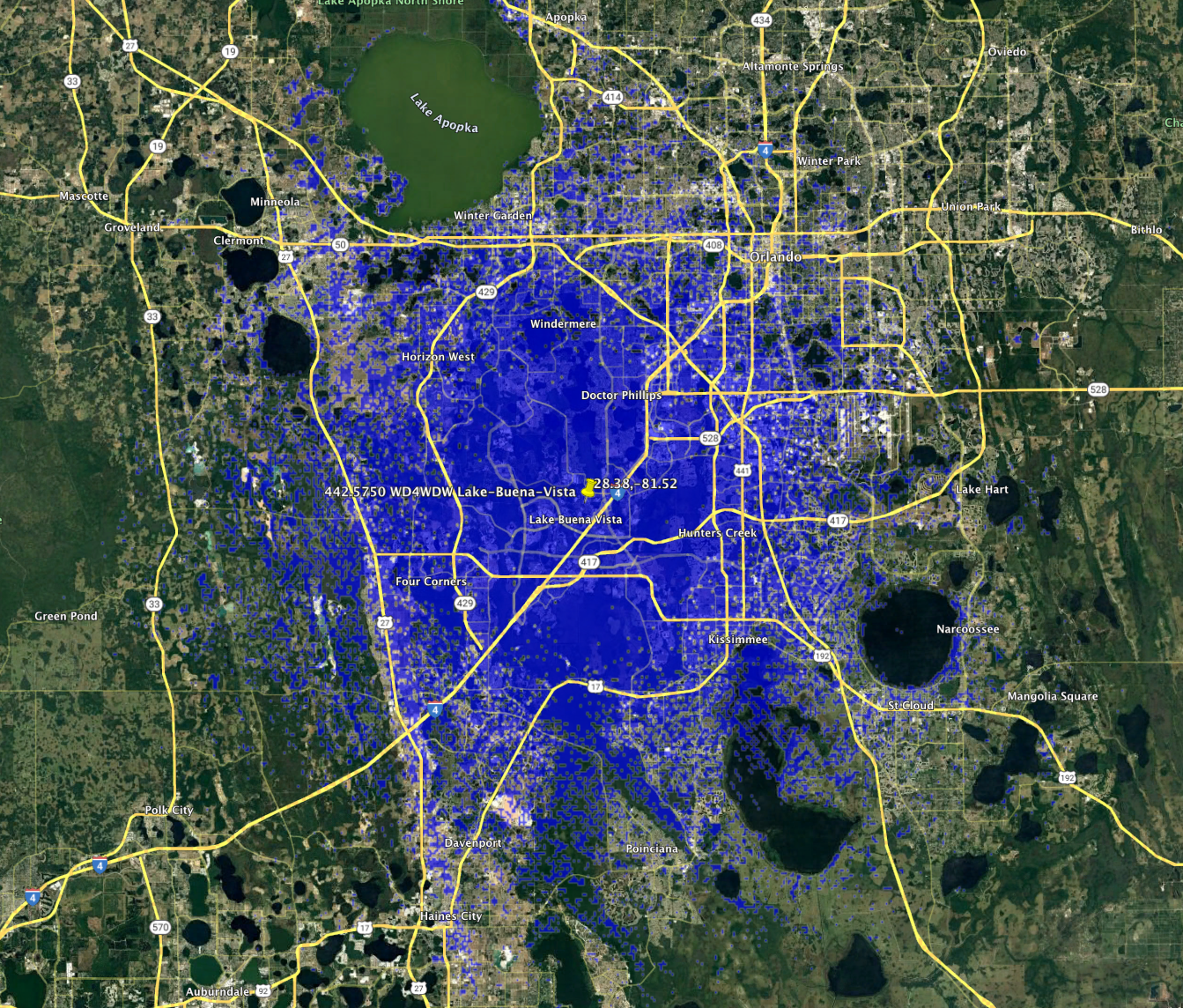
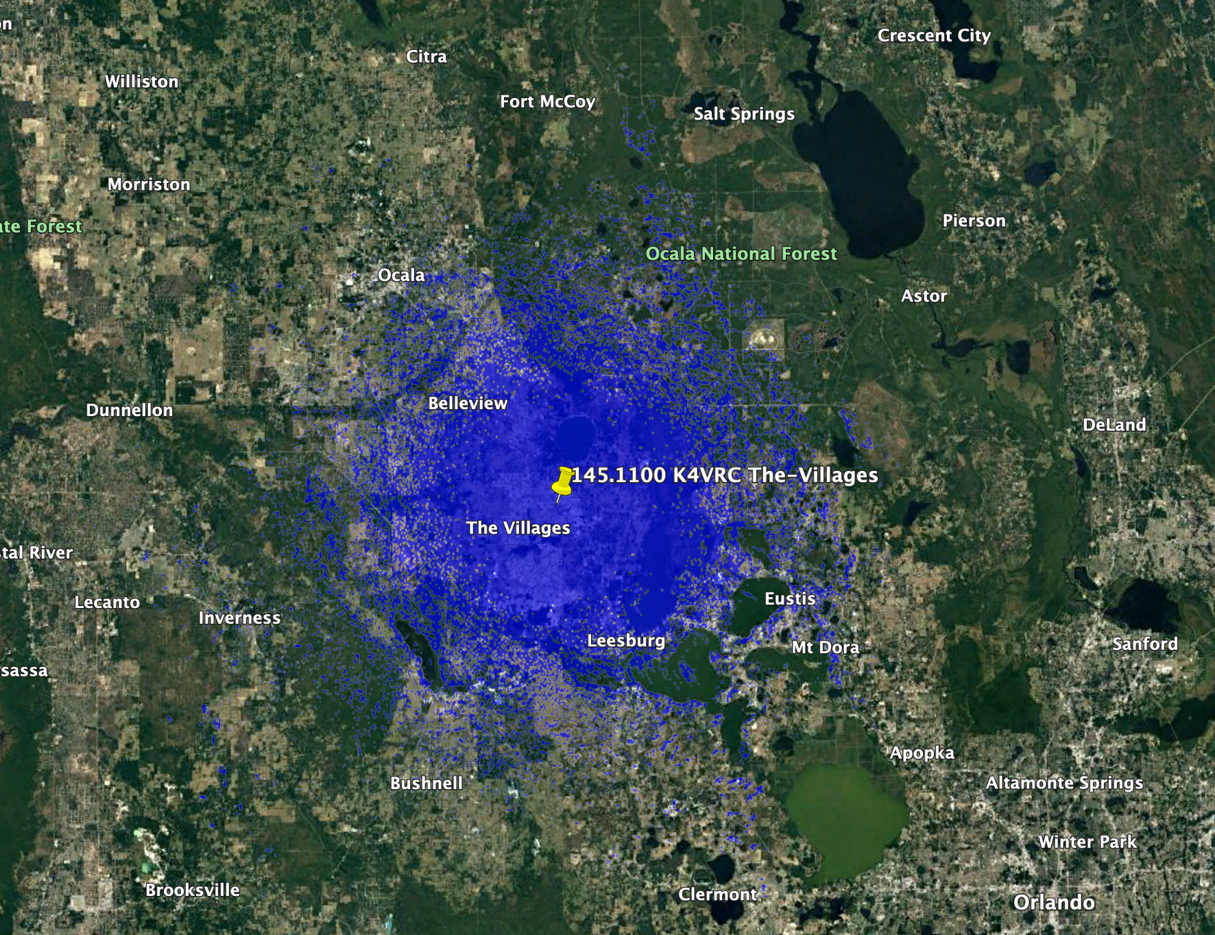
443.7000 in Sarasota transfer from K4JBV to KM4EC

443.7000 in Sarasota was held by William F Martin, K4JBV who has passed away. The Manatee County Emergency Support Group, Inc. has been authorized to take over this by his estate and we’ve transferred it to them.

443.7000 KM4EC Sarasota Service Contour
====FASMA COORDINATION RECORD 1287====

Record ID      : 1287
Coord Date     : 2023-02-28
Update Date    : 2023-02-28
Orig Cord Date : 2015-10-03
Holder         : Manatee County Emergency Support Group, Inc.
Trustee        : Jack W Ham, WG9X
URL            :
County         : Sarasota
City           : Sarasota
Lat, Lon       : 27.35, -82.48
Callsign       : KM4EC
Output Freq    : 443.7000 MHz
Input Freq     : 448.7000 MHz
Bandwidth      : 25.000 KHz
Emission 1     : 16K0F3E
Emission 2     :
ERP            : 100.0 Watts, +50 dBm
Antenna Height : 91.44 Meters
Access Tone Out: 82.5 Hz
Access Tone In : 82.5 Hz
Model          : https://plots.fasma.org/440/443.7000_KM4EC_Sarasota_1287.kmz
Service        : 44 km
Interference   : 87 km
Features       : o WBFM el 82.5/82.5

The coverage model is a standard KML format and may be viewed in google earth.
This is automatically generated based on your location, antenna height, ERP and
frequency.

New DMR repeater 442.7750 KE4PRF Seffner

This is a new DMR repeater in Seffner and it’s coverage area and information is below
442.7750_KE4PRF_Seffner
442.7750_KE4PRF_Seffner Service Contour
====FASMA COORDINATION RECORD 3653====

Record ID      : 3653
Coord Date     : 2023-01-15
Update Date    : 2023-01-15
Orig Cord Date : 2023-01-15
Holder         : Mark Andrews
Trustee        : Mark Andrews, KE4PRF
URL            : No URL On File
County         : Hillsborough
City           : Seffner
Lat, Lon       : 27.99, -82.30
Callsign       : KE4PRF
Output Freq    : 442.7750 MHz
Input Freq     : 447.7750 MHz
Bandwidth      : 12.500 KHz
Emission 1     : 7K60FXE
Emission 2     :
ERP            : 438.5 Watts, +56.42 dBm
Antenna Height : 13.00 Meters
DMR CC         : CC1 = 1, CC2 = 1
Model          : https://plots.fasma.org/440/442.7750_KE4PRF_Seffner_3653.kmz
Service        : 37 km
Interference   : 88 km
Features       : Solar Powered, DMR: Local (TS1, TG:1), Linked to Brandmiester
               : (TS1) and TGIF (TS2) networks.

The coverage model is a standard KML format and may be viewed in google earth.
This is automatically generated based on your location, antenna height, ERP and
frequency.
 			

442.5750 WD4WDW Lake Buena Vista Update

This is an update. This repeater has moved about 20km south from it’s old location.
442.5750_WD4WDW_Lake-Buena-Vista_1246 Service Area
====FASMA COORDINATION RECORD 1246====

Record ID      : 1246
Coord Date     : 2020-05-16
Update Date    : 2023-01-11
Orig Cord Date : 2015-05-16
Holder         : Disney Emergency Amateur Radio Service, Inc.
Trustee        : Kevin R. Tower, KD7OAB
URL            : https://www.wd4wdw.org
County         : Osceola
City           : Lake Buena Vista
Lat, Lon       : 28.38, -81.52
Callsign       : WD4WDW
Output Freq    : 442.5750 MHz
Input Freq     : 447.5750 MHz
Bandwidth      : 25.000 KHz
Emission 1     : 16K0F3E
Emission 2     : 7K60FXE
ERP            : 33.7 Watts, +45.28 dBm
Antenna Height : 28.00 Meters
Access Tone Out: 103.5 Hz
Access Tone In : 103.5 Hz
DMR CC         : CC1 = 3, CC2 = 3
Model          : https://plots.fasma.org/440/442.5750_WD4WDW_Lake-Buena-Vista_1246.kmz
Service        : 28 km
Interference   : 70 km
Features       : DMR is Brandmeister-connected.

The coverage model is a standard KML format and may be viewed in google earth.
This is automatically generated based on your location, antenna height, ERP and
frequency.

FASMA Two-Meter Survey

FASMA is soliciting input from amateurs in Florida regarding the current use of the Two-Meter Band. As part of this, FASMA undertook extensive research into the history of amateur Two-Meter operations.

A video summary of this research was also produced. Many early decisions and equipment limitations shaped our present use of the use of the Two-Meter band. FASMA seeks to understand how amateurs are using Two-Meters in their current operations.

We want input from all users; voice, weak-signal, repeaters, packet, satellite and experimental.

FASMA has created a brief survey open to all Two-Meter users in Florida.
Please register and take it at this link.

The survey will run through the 2022/2023 and will help us understand if the current band plan fits actual use. The survey is 25 questions and should take no more than 15 minutes. We’ll publish our findings in 2023.

In the spirit of discussion FASMA has a public email list that any interested party may join.

145.1100 K4VRC The Villages

This is a new FM Voice repeater in The Villages. It is coordinated pending no interference with WD4WDW #1105 in Lake Buena Vista.
145.1100_K4VRC The Villages 3652 Service Area
145.1100 K4VRC The Villages 3652 Service Area
====FASMA COORDINATION RECORD 3652====

Record ID      : 3652
Coord Date     : 2022-11-14
Update Date    : 2022-11-14
Orig Cord Date : 2022-11-14
Holder         : VILLAGES AMATEUR RADIO CLUB
Trustee        : George W. Briggs, K2DM
URL            : http://www.k4vrc.com
County         : Sumter
City           : The Villages
Lat, Lon       : 28.95, -81.96
Callsign       : K4VRC
Output Freq    : 145.1100 MHz
Input Freq     : 144.5100 MHz
Bandwidth      : 20.000 KHz
Emission 1     : 16K0F3E
Emission 2     :
ERP            : 67.1 Watts, +48.27 dBm
Antenna Height : 34.40 Meters
Access Tone Out: 107.2 Hz
Access Tone In : 107.2 Hz
Model          : https://plots.fasma.org/144/145.1100_K4VRC_The-Villages_3652.kmz
Service        : 30 km
Interference   : 80 km

The coverage model is a standard KML format and may be viewed in google earth.
This is automatically generated based on your location, antenna height, ERP and
frequency.

442.0125 KG1AES Homestead New Coordination

This is a new coordination granted to KG1AES in Homestead. It is a P25 Phase 1 and NBFM repeater.
442.0125 KG1AES Homestead Service Contour
====FASMA COORDINATION RECORD 3648====

Record ID      : 3648
Coord Date     : 2022-10-30
Update Date    : 2022-10-30
Orig Cord Date : 2022-10-30
Holder         : Austin Jewsbury
Trustee        : Austin Jewsbury, KG1AES
URL            : No URL On File
County         : Miami-Dade
City           : Homestead
Lat, Lon       : 25.47, -80.47
Callsign       : KG1AES
Output Freq    : 442.0125 MHz
Input Freq     : 447.0125 MHz
Bandwidth      : 12.500 KHz
Emission 1     : 8K10F1E
Emission 2     : 11K2F3E
ERP            : 346.7 Watts, +55.4 dBm
Antenna Height : 97.50 Meters
DCS CODE       : 565
P25 NAC TX     : 0xA55
P25 NAC RX     : 0xA55
Model          : https://plots.fasma.org/440/442.0125_KG1AES_Homestead_3648.kmz
Service        : 54 km
Interference   : 103 km
Features       : P25 Phase 1

The coverage model is a standard KML format and may be viewed in google earth.
This is automatically generated based on your location, antenna height, ERP and
frequency.

442.1250 KM4EC Bradenton Updated

Manatee County Emergency Support Group, Inc. has updated the trustee and holder for this coordination. With the new model data their coverage area has increased from 26 to 41 km!
442.1250 KM4EC Bradenton Service Contour
====FASMA COORDINATION RECORD 280====

Record ID      : 280
Coord Date     : 2022-10-30
Update Date    : 2022-10-30
Orig Cord Date : 1995-08-17
Holder         : Manatee County Emergency Support Group, Inc.
Trustee        : Jack W Ham, WG9X
URL            : https://www.mcesg.org/
County         : Manatee
City           : Bradenton
Lat, Lon       : 27.49, -82.36
Callsign       : KM4EC
Output Freq    : 442.1250 MHz
Input Freq     : 447.1250 MHz
Bandwidth      : 25.000 KHz
Emission 1     : 16K0F3E
Emission 2     :
ERP            : 245.5 Watts, +53.9 dBm
Antenna Height : 45.72 Meters
Access Tone Out: 100.0 Hz
Access Tone In : 100.0 Hz
Model          : https://plots.fasma.org/440/442.1250_KM4EC_Bradenton_280.kmz
Service        : 41 km
Interference   : 94 km
Features       : o WBFM ersz 100.0/100.0

The coverage model is a standard KML format and may be viewed in google earth.
This is automatically generated based on your location, antenna height, ERP and
frequency. 
			

147.1950 KM4EC Bradenton Updated

Manatee County Emergency Support Group, Inc. has updated the trustee and holder for this coordination.
147.1950_KM4EC_Bradenton Service Contour
147.1950 KM4EC Bradenton Service Contour
   
====FASMA COORDINATION RECORD 151====

Record ID      : 151
Coord Date     : 2019-12-04
Update Date    : 2022-10-30
Orig Cord Date : 1984-12-04
Holder         : Manatee County Emergency Support Group, Inc.
Trustee        : Jack W Ham, WG9X
URL            : https://www.mcesg.org/
County         : Manatee
City           : Bradenton
Lat, Lon       : 27.48, -82.62
Callsign       : KM4EC
Output Freq    : 147.1950 MHz
Input Freq     : 147.7950 MHz
Bandwidth      : 15.000 KHz
Emission 1     : 16K0F3E
Emission 2     :
ERP            : 125.9 Watts, +51 dBm
Antenna Height : 26.52 Meters
Access Tone Out: 103.5 Hz
Access Tone In : 103.5 Hz
Model          : https://plots.fasma.org/144/147.1950_KM4EC_Bradenton_151.kmz
Service        : 33 km
Interference   : 86 km
Adjacent 1     : 27 km
Features       : o WBFM ers 103.5/103.5