443.7000 in Sarasota transfer from K4JBV to KM4EC

443.7000 in Sarasota was held by William F Martin, K4JBV who has passed away. The Manatee County Emergency Support Group, Inc. has been authorized to take over this by his estate and we’ve transferred it to them.

443.7000 KM4EC Sarasota Service Contour
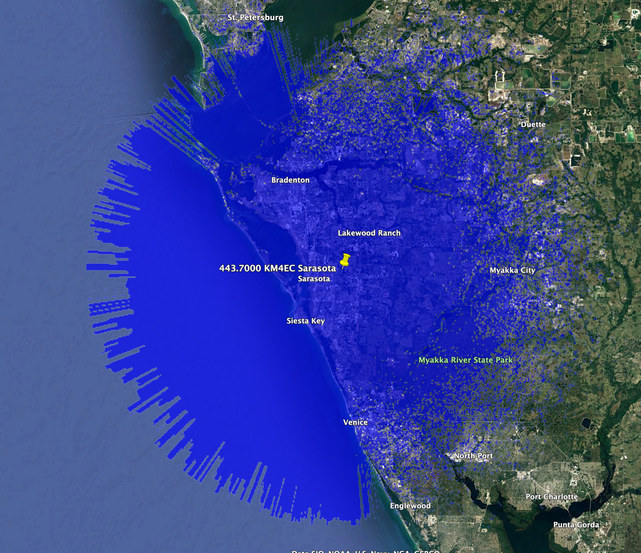
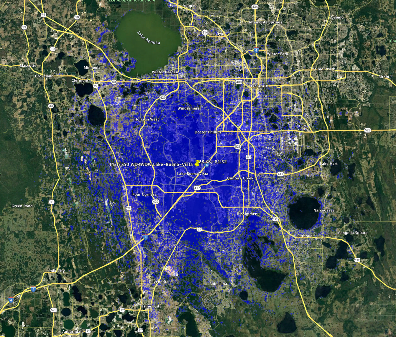
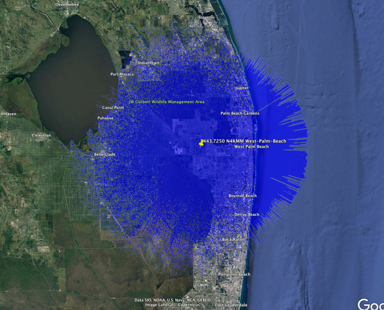
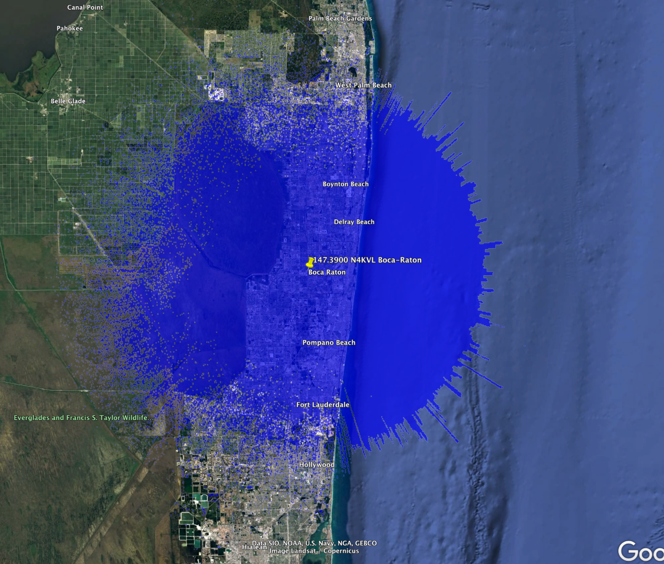
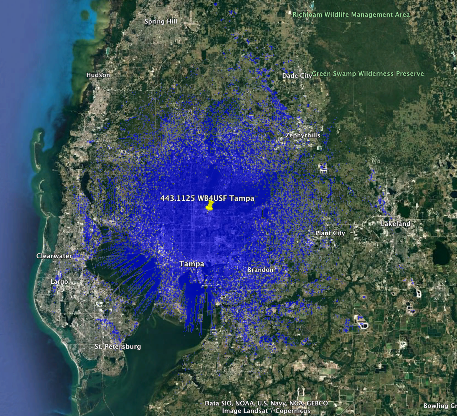
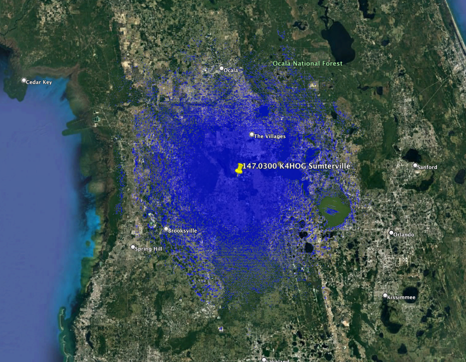
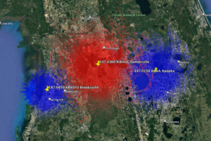
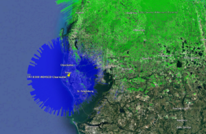
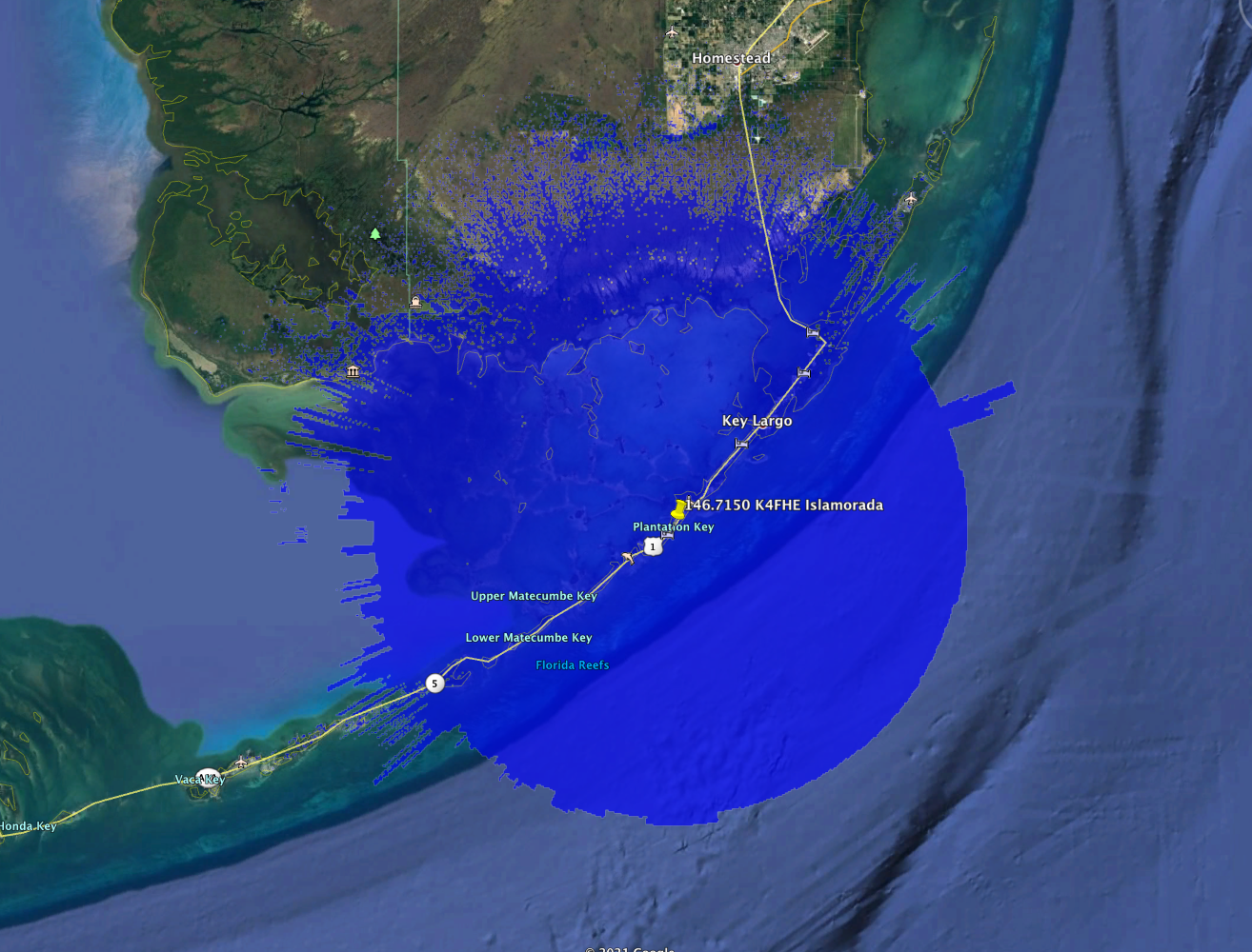
====FASMA COORDINATION RECORD 1287====

Record ID      : 1287
Coord Date     : 2023-02-28
Update Date    : 2023-02-28
Orig Cord Date : 2015-10-03
Holder         : Manatee County Emergency Support Group, Inc.
Trustee        : Jack W Ham, WG9X
URL            :
County         : Sarasota
City           : Sarasota
Lat, Lon       : 27.35, -82.48
Callsign       : KM4EC
Output Freq    : 443.7000 MHz
Input Freq     : 448.7000 MHz
Bandwidth      : 25.000 KHz
Emission 1     : 16K0F3E
Emission 2     :
ERP            : 100.0 Watts, +50 dBm
Antenna Height : 91.44 Meters
Access Tone Out: 82.5 Hz
Access Tone In : 82.5 Hz
Model          : https://plots.fasma.org/440/443.7000_KM4EC_Sarasota_1287.kmz
Service        : 44 km
Interference   : 87 km
Features       : o WBFM el 82.5/82.5

The coverage model is a standard KML format and may be viewed in google earth.
This is automatically generated based on your location, antenna height, ERP and
frequency.

442.5750 WD4WDW Lake Buena Vista Update

This is an update. This repeater has moved about 20km south from it’s old location.
442.5750_WD4WDW_Lake-Buena-Vista_1246 Service Area
====FASMA COORDINATION RECORD 1246====

Record ID      : 1246
Coord Date     : 2020-05-16
Update Date    : 2023-01-11
Orig Cord Date : 2015-05-16
Holder         : Disney Emergency Amateur Radio Service, Inc.
Trustee        : Kevin R. Tower, KD7OAB
URL            : https://www.wd4wdw.org
County         : Osceola
City           : Lake Buena Vista
Lat, Lon       : 28.38, -81.52
Callsign       : WD4WDW
Output Freq    : 442.5750 MHz
Input Freq     : 447.5750 MHz
Bandwidth      : 25.000 KHz
Emission 1     : 16K0F3E
Emission 2     : 7K60FXE
ERP            : 33.7 Watts, +45.28 dBm
Antenna Height : 28.00 Meters
Access Tone Out: 103.5 Hz
Access Tone In : 103.5 Hz
DMR CC         : CC1 = 3, CC2 = 3
Model          : https://plots.fasma.org/440/442.5750_WD4WDW_Lake-Buena-Vista_1246.kmz
Service        : 28 km
Interference   : 70 km
Features       : DMR is Brandmeister-connected.

The coverage model is a standard KML format and may be viewed in google earth.
This is automatically generated based on your location, antenna height, ERP and
frequency.

442.1250 KM4EC Bradenton Updated

Manatee County Emergency Support Group, Inc. has updated the trustee and holder for this coordination. With the new model data their coverage area has increased from 26 to 41 km!
442.1250 KM4EC Bradenton Service Contour
====FASMA COORDINATION RECORD 280====

Record ID      : 280
Coord Date     : 2022-10-30
Update Date    : 2022-10-30
Orig Cord Date : 1995-08-17
Holder         : Manatee County Emergency Support Group, Inc.
Trustee        : Jack W Ham, WG9X
URL            : https://www.mcesg.org/
County         : Manatee
City           : Bradenton
Lat, Lon       : 27.49, -82.36
Callsign       : KM4EC
Output Freq    : 442.1250 MHz
Input Freq     : 447.1250 MHz
Bandwidth      : 25.000 KHz
Emission 1     : 16K0F3E
Emission 2     :
ERP            : 245.5 Watts, +53.9 dBm
Antenna Height : 45.72 Meters
Access Tone Out: 100.0 Hz
Access Tone In : 100.0 Hz
Model          : https://plots.fasma.org/440/442.1250_KM4EC_Bradenton_280.kmz
Service        : 41 km
Interference   : 94 km
Features       : o WBFM ersz 100.0/100.0

The coverage model is a standard KML format and may be viewed in google earth.
This is automatically generated based on your location, antenna height, ERP and
frequency. 
			

147.1950 KM4EC Bradenton Updated

Manatee County Emergency Support Group, Inc. has updated the trustee and holder for this coordination.
147.1950_KM4EC_Bradenton Service Contour
147.1950 KM4EC Bradenton Service Contour
   
====FASMA COORDINATION RECORD 151====

Record ID      : 151
Coord Date     : 2019-12-04
Update Date    : 2022-10-30
Orig Cord Date : 1984-12-04
Holder         : Manatee County Emergency Support Group, Inc.
Trustee        : Jack W Ham, WG9X
URL            : https://www.mcesg.org/
County         : Manatee
City           : Bradenton
Lat, Lon       : 27.48, -82.62
Callsign       : KM4EC
Output Freq    : 147.1950 MHz
Input Freq     : 147.7950 MHz
Bandwidth      : 15.000 KHz
Emission 1     : 16K0F3E
Emission 2     :
ERP            : 125.9 Watts, +51 dBm
Antenna Height : 26.52 Meters
Access Tone Out: 103.5 Hz
Access Tone In : 103.5 Hz
Model          : https://plots.fasma.org/144/147.1950_KM4EC_Bradenton_151.kmz
Service        : 33 km
Interference   : 86 km
Adjacent 1     : 27 km
Features       : o WBFM ers 103.5/103.5
			

443.7250 N4KMM West Palm Beach

This DMR repeater has been in operation for a few years and recently changed frequencies to 443.7250.
443.7250 N4KMM West Palm Beach Service Contour
====FASMA COORDINATION RECORD 1487====

Record ID      : 1487
Coord Date     : 2022-08-11
Update Date    : 2022-08-11
Orig Cord Date : 2019-11-17
Holder         : Sean M. Robert, N4KMM
Trustee        : Sean Robert, K4KMM
URL            : No URL On File
County         : Palm Beach
City           : West Palm Beach
Lat, Lon       : 26.71, -80.27
Callsign       : N4KMM
Output Freq    : 443.7250 MHz
Input Freq     : 448.7250 MHz
Bandwidth      : 12.500 KHz
Emission 1     : 7K60FXE
Emission 2     :
ERP            : 447.7 Watts, +56.51 dBm
Antenna Height : 60.10 Meters
DMR CC         : CC1 = 1, CC2 = 1
Model          : https://plots.fasma.org/440/443.7250_N4KMM_West-Palm-Beach_1487.kmz
Service        : 49 km
Interference   : 96 km

The coverage model is a standard KML format and may be viewed in google earth.
This is automatically generated based on your location, antenna height, ERP and
frequency.

Florida Amateur Spectrum Management Association, Inc.

147.3900 N4KVL Boca Raton

This is a dual mode WBFM and P25 repeater. It was transferred from Mark Filla N4DES as record 457 to the new holder at his request. FASMA updated this and granted the new coordination as #3645
147.3900_N4KVL_Boca-Raton_3645
147.3900_N4KVL_Boca-Raton_3645 service contour
====FASMA COORDINATION RECORD 3645====

Record ID      : 3645
Coord Date     : 2022-08-10
Update Date    : 2022-08-10
Orig Cord Date : 2022-08-10
Holder         : Sean Robert
Trustee        : Sean Robert, N4KVL
URL            :
County         : Palm Beach
City           : Boca Raton
Lat, Lon       : 26.37, -80.17
Callsign       : N4KVL
Output Freq    : 147.3900 MHz
Input Freq     : 147.9900 MHz
Bandwidth      : 15.000 KHz
Emission 1     : 16K0F3E
Emission 2     : 8K10F1E
ERP            : 171.0 Watts, +52.33 dBm
Antenna Height : 91.40 Meters
Access Tone Out: 110.9 Hz
Access Tone In : 110.9 Hz
P25 NAC TX     : 0x293
P25 NAC RX     : 0x293
Model          : https://plots.fasma.org/144/147.3900_N4KVL_Boca-Raton_3645.kmz
Service        : 46 km
Interference   : 67 km
Adjacent 1     : 39 km

The coverage model is a standard KML format and may be viewed in google earth.
This is automatically generated based on your location, antenna height, ERP and
frequency.

Florida Amateur Spectrum Management Association, Inc.

443.1125 WB4USF Tampa

This is a new DMR repeater at the USF Amateur Radio Club.
443.1125_WB4USF_Tampa_3644
443.1125 WB4USF Tampa Service Contour
====FASMA COORDINATION RECORD 3644====

Record ID      : 3644
Coord Date     : 2022-08-10
Update Date    : 2022-08-10
Orig Cord Date : 2022-08-10
Holder         : Amateur Radio Club At USF
Trustee        : Corey Clark, N4FQ
URL            : https://bullsconnect.usf.edu/amateurradio/home/
County         : Hillsborough
City           : Tampa
Lat, Lon       : 28.06, -82.42
Callsign       : WB4USF
Output Freq    : 443.1125 MHz
Input Freq     : 448.1125 MHz
Bandwidth      : 12.500 KHz
Emission 1     : 11K2F3E
Emission 2     : 7K60FXE                                                                                                    |
ERP            : 101.6 Watts, +50.07 dBm
Antenna Height : 26.00 Meters
Access Tone Out: 146.2 Hz
Access Tone In : 146.2 Hz
DMR CC         : CC1 = 2, CC2 = 2
Model          : https://plots.fasma.org/440/443.1125_WB4USF_Tampa_3644.kmz
Service        : 30 km
Interference   : 76 km

The coverage model is a standard KML format and may be viewed in google earth.
This is automatically generated based on your location, antenna height, ERP and
frequency.

Florida Amateur Spectrum Management Association, Inc.

147.0300 K4HOG Sumterville 3595 Update

This repeater was moved to a higher tower and about 27 kM south.  The coordination was updated to reflect this.  Adjacent users are protected from new harmful interference. https://k4hog.org
147.0300_K4HOG_Sumterville_3595 Service Contour
147.0300_K4HOG_Sumterville_3595 adjacent
147.0300_K4HOG_Sumterville_3595 co-channel


====FASMA COORDINATION RECORD 3595====

Record ID      : 3595
Coord Date     : 2021-04-11
Update Date    : 2022-03-11
Orig Cord Date : 1997-09-09
Holder         : Hog County Amateur Radio Association, Inc
Trustee        : Gene E. King, KI4LEH
URL            : https://k4hog.org
County         : Sumter
City           : Sumterville
Lat, Lon       : 28.76, -82.06
Callsign       : K4HOG
Output Freq    : 147.0300 MHz
Input Freq     : 147.6300 MHz
Bandwidth      : 15.000 KHz
Emission 1     : 16K0F3E
Emission 2     :
ERP            : 130.0 Watts, +51.14 dBm
Antenna Height : 115.80 Meters
Access Tone Out: 123.0 Hz
Access Tone In : 123.0 Hz
Model          : https://plots.fasma.org/144/147.0300_K4HOG_Sumterville_3595.kmz
Service        : 53 km
Interference   : 101 km
Adjacent 1     : 48 km
Features       : AllStar: 49829
               : Echolink Node: 294541
               : Emergency Power
               : Weather
               : RACES/ARES
               : Wide Area

The coverage model is a standard KML format and may be viewed in google earth.
This is automatically generated based on your location, antenna height, ERP and
frequency.

145.1500 WB4TWQ Miami De-Coordinated

This repeater has been confirmed off air by FASMA spectrum monitors and the trustee has failed to respond to repeated requests for updates since Jun 2020. As FASMA has no updates, this repeater is de-coordinated.
====FASMA COORDINATION RECORD 360====

Record ID      : 360
Coord Date     : 2019-11-27
Update Date    : 2016-09-30
Orig Cord Date : 1996-11-27
Holder         : Francisco Cabrera, WB4TWQ
Trustee        : Francisco Cabrera, WB4TWQ
URL            :
County         : Miami-Dade
City           : Miami
Lat, Lon       : 25.87, -80.27
Callsign       : WB4TWQ
Output Freq    : 145.1500 MHz
Input Freq     : 144.5500 MHz
Bandwidth      : 20.000 KHz
Emission 1     : 16K0F3E
Emission 2     :
ERP            : 500.0 Watts, +56.99 dBm
Antenna Height : 106.68 Meters
Access Tone Out: ERROR: TONE IS UNSET, PLEASE UPDATE RECORD!
Access Tone In : ERROR: TONE IS UNSET, PLEASE UPDATE RECORD!
Model          : https://plots.fasma.org/144/145.1500_WB4TWQ_Miami_360.kmz
Service        : ERROR: SERVICE MISSING km
Interference   : ERROR: INTERFERENCE MISSING km

146.7150 K4FHE Islamorada

This is an update to the record 103 N9LCK repeater. It is only an update of trustee and callsign as N9LCK has moved from the area.
146.7150 K4FHE Islamorada Service Contour
====FASMA COORDINATION RECORD 3602====

Record ID      : 3602
Coord Date     : 2021-04-20
Update Date    : 2021-04-20
Orig Cord Date : 1984-11-03
Holder         : Florida Keys Amateur Radio Club
Trustee        : Steve Tolf, K1ST
URL            : http://www.k4flk.org/
County         : Monroe
City           : Islamorada
Lat, Lon       : 24.98, -80.55
Callsign       : K4FHE
Output Freq    : 146.7150 MHz
Input Freq     : 146.1150 MHz
Bandwidth      : 15.000 KHz
Emission 1     : 16K0F3E
Emission 2     : 
ERP            : 187.5 Watts, +52.73 dBm
Antenna Height : 91.00 Meters
Access Tone Out: 94.8 Hz
Access Tone In : 94.8 Hz
Model          : https://plots.fasma.org/144/146.7150_K4FHE_Islamorada_3602.kmz
Service        : 39 km
Interference   : 91 km
Adjacent 1     : 33 km
Features       : Monroe County Linked Repeater System 

The coverage model is a standard KML format and may be viewed in google earth.  
This is automatically generated based on your location, antenna height, ERP and
frequency.

Florida Amateur Spectrum Management Association, Inc.